Walk 4

Main content start

Towards Grimley and Lower Broadheath

Walks around the edge of the parish including Grimley and Lower Broadheath.

There are three length options of 3.9, 4.8 and 6.8 miles.

The routes start from the village green, all have stiles and it can be muddy. This is NOT a route to be done if there have been recent floods along the river. Please read the walk notes concerning this.

Points of interest include a river section and opportunities for bird watching.

Download GPX track – Walk 4 Around Grimley

Download GPX track – Walk 4 Around Hallow

Download GPX track – Walk 4 Towards Lower Broadheath

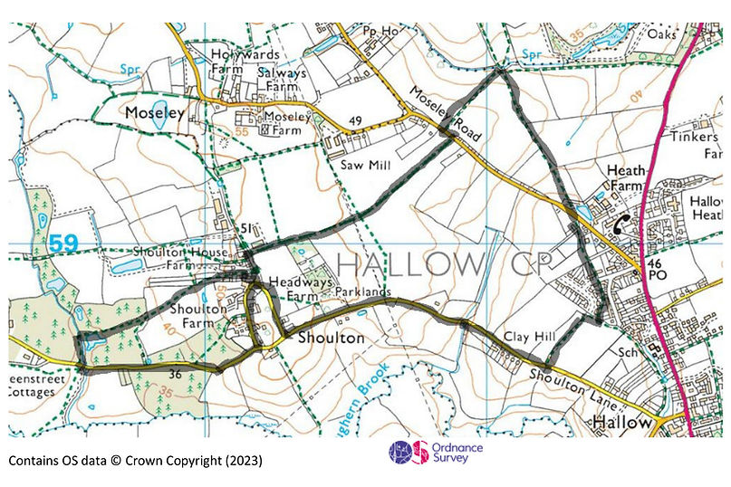
Route Map

Ordnance Survey map showing Shoulton, Hallow, farms, and roads in a rural area near Worcester.

Directions Walk A- 2.3 miles, 4 stiles

Start opposite Shoulton House Farm, (///wallet.snowballs.compelled on What3words). Walk North, away from Shoulton Lane and take the bridleway on the right in front of the farm sheds The finger post showing the way is covered in vegetation). Walk along this track until you get to a road (Moseley Road). Turn left at this junction and in a few yards take the footpath signed on the right. Go in this direction alongside a fence on your left.

At the end of the field, follow the edge of the field around to the right. You will come to a large metal gate, turn right in front of the gate and walk back up the other side of the field. This time the hedge will be on your left. Continue until you get to a stile with a gate to the right of it. Go over the stile if the gate is shut and cannot be easily opened. The path goes diagonally across this field to the right, towards a gate in the top right hand corner of the field. Go through the wooden gate.

You are now almost back onto Moseley Road but the footpath crosses the drive here and goes between the conifer on your left and the hedge on your right. Just after this, there is a gate opposite you which takes you onto Moseley Road which you now cross.

Take the first track on your right, immediately after the 30-mph speed limit sign and then go left in front of the farm building and over a stile. Continue and go over the next stile. Follow the path until you come to a roadand cross the road to continue on the path on the other side (by Oakleigh Heath sign).

Go through a wooden gate to reach a T junction and a field. Follow the path round to the right and continue around the field until you reach a road (Shoulton Lane). Turn right here and continue on the road until you reach another road on your right signed Shoulton. Turn right here and follow the road round to the right until you get back to the start.

Directions for extension to Walk 3 – Fields Around Shoulton- 1.1 miles, 2 stiles

Start just before the start of walk 1, at a footpath sign by the property ‘Two Hoots’. (///sprays.thruster.loser on What3words). Take this path and go through two large gates crossing a property. The waymarks through these gates are missing.

Continue straight until you see a green sign showing you the way, go through the metal gate on your left. Continue straight through another waymarked metal gate, over a wooden bridge and then a wooden stile. You now need to head diagonally right across the field towards the wood at the bottom. Keep the single oak tree on your left as you walk across the field heading towards a large dead tree with two branches sticking up. About 10m to the right of the dead tree you will see the next stile that you have to cross.

Ignoring all paths on both sides, continue straight ahead eventually coming to a small lake on your left. Cross the 1st stream using a wooden bridge. You will see a wooden bench on your left but continue straight ahead (ignoring more paths) and cross another stream. Immediately after the second stream, turn left at a T junction and carry on this path until you go through a metal gate* to meet the road. Turn left and take the next road on the left signed Shoulton. Continue along this road, keeping left, until you are back where you started.

*although not a public footpath, people have historically turned left in front of the metal gate and walked parallel to the road, with the hedge on the right, until this path meets a track with a footpath sign. You can join the road at this point and continue as above.

Useful Information

Information on using GPX tracks

How to use What 3Words

Hallow Farm Heritage Walk

1 mile (Worcestershire County Council walk)

PDF Download Link here

© Crown copyright [and database rights]

[2023] OS [CS-409732-H8S8N3]. You are granted a non-exclusive, royalty free, revocable licence solely to view the Licensed Data for non-commercial purposes for the period during which [Hallow Parish Council] makes it available. You are not permitted to copy, sub-license, distribute, sell or otherwise make available the Licensed Data to third parties in any form. Third party rights to enforce the terms of this licence shall be reserved to OS.

Footer start